K2 North Ridge from China: Route, History, Approach & 10 Reasons to Climb It (2027 Guide)
By Blake Penson · May 1, 2022
Category: route-comparisons
10 min read
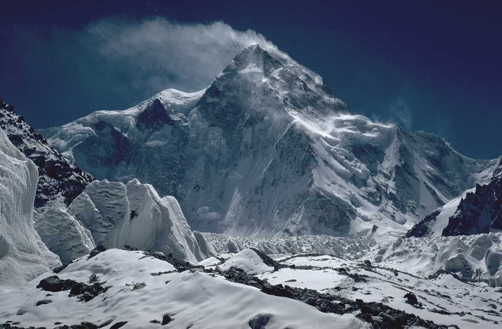
Yes, K2 can be climbed from China. The main route on the Chinese side is the North Ridge, a long, steep, continuous spur that rises about 3,500 m from the K2 Glacier in Xinjiang straight to the 8,611 m (28,251 ft) summit. It was first climbed by a Japanese expedition on 14 August 1982. Reaching it takes about a week by road and camel from Kashgar, over the Aghil Pass and along the Shaksgam valley, to a base camp at about 3,900 m. The route avoids the Bottleneck that dominates the Pakistani side. In exchange it is longer, more technical, far more remote and rarely climbed: in a typical decade only a handful of teams attempt it, against hundreds of climbers each summer on the Abruzzi Spur. For experienced high-altitude climbers who want quiet, a cultural journey across Central Asia and a "real climb" rather than a queue on fixed ropes, K2's north side is one of the great 8,000 m objectives.
This guide explains the North Ridge route and its history, how the approach works, how it compares with the standard Pakistani routes, and when and how to go. It also gives the 10 reasons, first shared with ExpedReview by expedition leader Ed "Iggy" Hannam of Feeding the Rat Expeditions, why experienced climbers choose it.
| Summit | 8,611 m (28,251 ft), world's second-highest |
| Country (north side) | China (Xinjiang Uyghur Autonomous Region) |
| Main route | North Ridge (sometimes called the North Spur or North Pillar) |
| First ascent of route | 14 August 1982, Japanese expedition (Naoe Sakashita, Hiroshi Yoshino, Yukihiro Yanagisawa) |
| Approach | Kashgar → road to Ilik/Yilik → camel trek over the Aghil Pass → Shaksgam valley → K2 Glacier |
| Chinese base camp | about 3,850 m (12,650 ft) on the Shaksgam River, the 1982 Japanese 'Base Home' (AAJ) |
| Advanced base camp | about 4,900 m (16,075 ft) on the K2 Glacier (1982 AAJ report) |
| Season | July–August (summer) |
| Typical expedition length | ~8–10 weeks including travel |
| Character | Steep, sustained snow, ice and rock; long and remote; no Bottleneck |
Can K2 be climbed from China?
Yes. K2 sits on the border between Pakistan (Gilgit-Baltistan) and China (Xinjiang). Almost all climbers approach from Pakistan, flying to Skardu and trekking up the Baltoro Glacier to the Abruzzi Spur or Cesen route. The Chinese side is the mountain's wild north face. The most climbed line there is the North Ridge, a prominent spur rising from the K2 Glacier to the summit.
Climbing from China needs a permit from the Chinese mountaineering authorities (through the Chinese Mountaineering Association and Xinjiang's sports bureau), a liaison officer, and a local logistics team for the long road and camel approach. Permits are much rarer than on the Pakistani side, and access depends on Chinese policy. In 2026, for example, China kept Everest's Tibetan side closed to foreign climbers. Anyone considering the north side should confirm current access with an experienced operator first.
K2 North Ridge history
| Year | Event |
|---|---|
| 1937 | British explorer Eric Shipton maps the Shaksgam and the north side of K2 |
| 1982 | First ascent of the North Ridge (14 Aug) by a large Japanese expedition. Naoe Sakashita, Hiroshi Yoshino and Yukihiro Yanagisawa reach the summit; Yanagisawa dies on the descent. More team members summit the next day |
| 1983 | Italian expedition makes the second ascent of the North Ridge |
| 1990 | Japanese team climbs a new line on the north-west face/ridge from China |
| 1990s–2000s | Occasional expeditions from Kazakhstan, Russia, Spain, Italy and elsewhere |
| 2007 | Russian team climbs a direct line on the West Face (from the Pakistan side) |
| 2011 | Gerlinde Kaltenbrunner summits via the North Ridge without supplemental oxygen, becoming the first woman to climb all 14 eight-thousanders without bottled oxygen |
| 2010s–2020s | A small number of commercial and private expeditions, including Feeding the Rat Expeditions |
Ascent totals for the North Ridge are not published in a single official source. The route has seen only a small fraction of K2's 964 summits recorded to the end of 2025.
How the North Ridge route works
The approach: Kashgar to base camp
- Kashgar (1,290 m). Expeditions usually begin in this historic Silk Road city in western Xinjiang. Climbers meet the logistics team, buy supplies and complete permit formalities.
- By road to the roadhead. A long drive along the Karakoram Highway and side roads leads towards the villages of Ilik (Yilik) and Mazar in the Yarkand River valley.
- Camel trek. From the roadhead, Bactrian camels carry gear over the Aghil Pass and down into the Shaksgam valley, then up the K2 River.
- Chinese base camp (about 3,850 m). The 1982 Japanese team put its 'Base Home' at 12,650 ft (about 3,850 m) on the Shaksgam River. It is much lower than Pakistani base camp, which helps recovery.
- Advanced base camp (about 4,900 m). In 1982 the Japanese carried four tons of supplies about ten miles (16 km) up to a base camp at 16,075 ft (about 4,900 m) on the K2 Glacier.
The Shaksgam River and its tributaries rise sharply with summer meltwater, and river crossings can limit when camels can travel. That is one reason the trek timing matters.
The climb
The North Ridge rises in an unbroken line from the glacier to the upper slopes of the north face. Typical features:
| Section | Approx. altitude | Character |
|---|---|---|
| ABC to Camp 1 | ~4,900–5,800 m | Glacier and lower ridge; crevasses and steep snow |
| Camp 1 to Camp 2 | ~5,800–6,600 m | Steep snow and ice on the ridge crest; mixed sections |
| Camp 2 to Camp 3 | ~6,600–7,550 m | Sustained steep ground; rock bands and ice |
| Camp 3 to Camp 4 | ~7,550–7,850 m | Upper ridge leading towards the hanging glacier of the north face |
| Camp 4 to summit | ~7,850–8,611 m | Snow slopes and a couloir (the "Japanese couloir") on the upper north face to the summit ridge |
Camp placements vary by team and conditions. Figures are approximate.
There are no queues, no Bottleneck and no serac traverse of the kind found on the Abruzzi Spur. But the ridge is steep almost all the way, there are few easy places to camp, and teams generally have to fix their own ropes or climb with a lighter, more alpine approach. Rescue is extremely difficult. There is no helicopter support of the kind sometimes available in Pakistan, and the nearest road is days away.
K2 north side vs south side
| North Ridge (China) | Abruzzi Spur / Cesen (Pakistan) | |
|---|---|---|
| Approach | Kashgar, road, then 5–7 day camel trek | Islamabad → Skardu → Askole, then ~7–8 day trek up the Baltoro |
| Base camp altitude | about 3,850 m (Shaksgam), with an upper base camp at about 4,900 m | ~5,000–5,150 m |
| Crowds | Very few teams; often alone | Dozens of teams and 100+ climbers in busy years |
| Key hazard | Steep, sustained terrain; remoteness; avalanche-prone upper face | Bottleneck and serac; rockfall lower down; crowding |
| Fixed ropes | Limited; team-fixed or alpine approach | Extensive commercial fixed lines |
| Rescue options | Very limited | Limited, but more options and teams nearby |
| Logistics | Chinese liaison, Kyrgyz/Uyghur camel teams | Balti porters, Pakistani and Nepali high-altitude staff |
| Permits | Chinese Mountaineering Association / Xinjiang authorities | Gilgit-Baltistan government / Alpine Club of Pakistan |
| Typical expedition length | ~8–10 weeks | ~7–9 weeks |
| Summits | A small number of teams per decade | Hundreds per decade (record ~200 in 2022) |
Read more about the Pakistani routes and their hazards in our K2 Bottleneck vs Khumbu Icefall comparison, and compare operators on our K2 page and Karakoram region page.
K2 north face, north ridge, north pillar and northeast ridge: what's the difference?
These terms are often confused:
- North Face: the huge face of K2 above the K2 Glacier in China.
- North Ridge (North Spur / North Pillar): the prominent spur on the left side of the north face. It is the standard Chinese route, first climbed in 1982.
- North-West Ridge / Face: lines further west on the Chinese side, such as the 1990 Japanese route.
- Northeast Ridge: a long ridge on the Pakistani–Chinese border, approached from the Godwin-Austen Glacier in Pakistan. A US team used it in 1978 for the third ascent of K2, finishing via the upper Abruzzi.
10 reasons to climb K2 from the north side
Ed "Iggy" Hannam of Feeding the Rat Expeditions, which runs trips to K2's north side, described these reasons to ExpedReview. We have summarised and added context in our own words.
1. Travel by camel
On Everest it is yaks, on the Baltoro it is porters and mules, and on K2's north side it is Bactrian camels. Their pace and needs shape the rhythm of the approach, and the Kyrgyz and Uyghur herders who run them become a central part of the expedition. Hannam's view is that the camels set the tone of the whole trip, echoing the caravans that crossed these mountains on the Silk Road for centuries.
2. Real quiet
There are no lodge villages, no helicopter traffic and few other expeditions. Rivers in the Shaksgam are broad and braided rather than roaring gorges. Climbers often say the silence is one of the most memorable parts of the trip.
3. Remarkable food
Expeditions stock up in Kashgar, where they can buy food from across China and Central Asia. Hannam's teams have used Sichuanese cooks alongside Uyghur and Kyrgyz staples such as hand-pulled noodles and stews. Food in base camp is a far cry from standard expedition fare.
4. Cleaner camps and trails
With so few visitors, the north side lacks the waste problems of busy 8,000 m base camps: no old latrines, no frozen rubbish and fewer contaminated water sources. Teams have a responsibility to keep it that way.
5. Campfires
Driftwood along the Shaksgam allows the occasional campfire, used sparingly and only where local herders already burn wood. That is a rarity on 8,000 m expeditions.
6. A route without the infrastructure
On busy 8,000 m routes, the same companies fix the same ropes in the same places every year. The North Ridge has none of that. Teams choose camp sites by conditions, the route changes year to year, and climbers actually climb instead of following a line of jumars. Hannam described it as the closest thing to "an accessible alpine ascent" on a steep 8,000 m peak.
7. Different people
The climbing team, the Chinese liaison officers, Kyrgyz camel handlers and Uyghur logistics staff each bring their own language and culture. Climbers drawn to the north side also tend to be a different crowd from the usual 8,000 m market, often with more alpine backgrounds.
8. Culture and history
The journey from Kashgar follows ancient trade and herding routes through the Pamir and Karakoram. Climbers learn greetings in several languages, ride camels, and see Central Asian culture first hand, not through the bubble of a commercial base camp.
9. Efficient logistics
Modern Chinese roads and communications make parts of the logistics surprisingly efficient. Road journeys that once took days take hours, weather data reaches base camp reliably, and supplies can be moved quickly to the roadhead. Once beyond the road, though, the expedition is entirely on its own.
10. A different gear list
With less fixed rope and more technical terrain, the North Ridge calls for a more alpine kit: lighter tents for small ledges, technical boots and crampons, different stoves and ropes. It suits climbers comfortable with real climbing at altitude. See our explainer on the difference between mountaineering and alpinism.
The geography of K2's north side
K2's north side drains into the Shaksgam valley, one of the most remote valleys in Asia. It lies between the main Karakoram crest to the south and the Aghil Range to the north. The area has been administered by China since the 1963 Sino-Pakistan boundary agreement, and India also claims it. Few roads reach it, and the valley has no permanent settlements, only seasonal herders.
The K2 Glacier (sometimes called the North K2 Glacier) flows north from the foot of the mountain to the Shaksgam River. From the north, K2 rises in one unbroken sweep of about 4,700 m from the valley floor to the summit. It is one of the largest relief differences on Earth over such a short distance, and many climbers think it is the mountain's most dramatic aspect. The British explorer Eric Shipton crossed the Aghil Pass and mapped the region in 1937, and his book Blank on the Map remains the classic account.
Summer meltwater makes the rivers dangerous to cross on foot. That is why camels, which can wade the braided channels, became the standard way to carry expedition loads. Later in the season, as glacial melt peaks, crossings can become impossible even for camels. Expeditions plan their walk-in and walk-out around this.
A sample K2 north side itinerary
| Days | Activity |
|---|---|
| 1–3 | Arrive in Kashgar (via Urumqi); permits, briefings, supplies |
| 4–5 | Drive to the roadhead near Ilik/Mazar; meet camel teams |
| 6–11 | Camel trek over the Aghil Pass and along the Shaksgam to Chinese base camp (about 3,850 m) |
| 12–14 | Rest, establish advanced base camp (about 4,900 m) |
| 15–45 | Fix the route and set up camps; acclimatisation rotations to Camp 2–3 |
| 46–60 | Rest and wait for a summit window; summit push from Camp 4 |
| 61–66 | Clear the mountain, walk out with camels |
| 67–70 | Drive to Kashgar; fly home |
Illustrative only. Real expeditions vary with conditions, team strength and permit dates.
Risks specific to K2's north side
The north side avoids the Bottleneck, but it has serious hazards of its own:
- Remoteness. The nearest road is several days away by camel, and helicopter rescue is effectively unavailable. A serious injury high on the ridge may be unsurvivable, so self-rescue skills and conservative decisions are essential.
- Steep, sustained ground. The ridge is steep from bottom to top, with few flat camp sites. Falls, rockfall and avalanches on the upper north face are all possible.
- Weather. K2's position makes it a magnet for storms, and the north side catches cold winds. Forecasts are available by satellite, but there is little margin when weather turns.
- River crossings. On the walk-in and walk-out, the Shaksgam and its tributaries can be hazardous. Timing and camel support matter.
- Small teams. With few or no other teams on the mountain, there is no one else to help if something goes wrong, and no shared fixed ropes.
- Political access. Permits depend on Chinese policy and can change at short notice. Teams sometimes cannot get permits at all.
Training for the K2 North Ridge
Climbers preparing for the North Ridge typically train for 12 months or more, combining high-volume endurance work with technical climbing. Useful preparation includes:
- Technical alpine routes at grade D/TD in the Alps or similar, especially steep snow, ice and mixed ground;
- Long days with heavy packs to simulate load carries between camps;
- High-altitude experience on at least one or two 8,000 m peaks, ideally including a technical one;
- Self-rescue and rope skills, because team-fixed ropes and small teams mean more responsibility for each climber;
- Cold-weather camping on small ledges and in exposed sites.
Who should consider K2's north side?
The North Ridge is not a first 8,000 m peak. Most climbers who attempt it have:
- several 8,000 m summits, often including a technical one such as K2's south side, Makalu or Kangchenjunga;
- solid alpine climbing skills on steep snow, ice and mixed terrain;
- experience of remote, self-sufficient expeditions where rescue may not be possible;
- the flexibility for an expedition of up to 10 weeks.
Climbers still building towards K2 often start with peaks such as Manaslu, Gasherbrum I, Ama Dablam or Everest. See our guides to how the body copes above 8,000 metres and what happens in the death zone.
K2 by the numbers
| Statistic | Figure |
|---|---|
| Height | 8,611 m (28,251 ft) |
| World rank | 2nd highest; highest in the Karakoram |
| First ascent | 31 July 1954 (Achille Compagnoni and Lino Lacedelli, Abruzzi Spur) |
| First ascent from China (North Ridge) | 14 August 1982 (Japanese expedition) |
| First winter ascent | 16 January 2021 (Nepali team led by Nirmal Purja and Mingma G) |
| Total summits (all routes) | 964 to end of 2025 (Broad Peak Adventures compilation) |
| Record season | ~200 summits in 2022 |
| 2025 season | 42 summits, 2 deaths (rockfall on the Pakistan side) |
| Nickname | "The Savage Mountain" |
Why most climbers still choose the Pakistan side
Despite the north side's appeal, the vast majority of K2 climbers go from Pakistan, for several practical reasons:
- Infrastructure. Commercial operators fix ropes from base camp to summit every summer, so clients can climb in expedition style with Sherpa and Pakistani support.
- Access. Pakistani permits are much easier to get than Chinese ones, and the Baltoro trek, though long, is well established.
- Cost and team sizes. Large commercial teams share the costs of rope fixing, oxygen and logistics.
- Rescue options. Military helicopters can sometimes reach base camp and lower camps on the Pakistan side. That is not possible in the Shaksgam.
- Combining peaks. Climbers can link K2 with Broad Peak or the Gasherbrums from the same Baltoro base area.
For many climbers the Pakistan side is a stepping stone. Once they have climbed K2 or other Karakoram peaks from the south, the North Ridge becomes a goal for a future, more adventurous expedition.
Planning a K2 north side expedition
| Planning item | What to expect |
|---|---|
| Season | July–August; camel crossings and river levels affect timing |
| Permit | Through Chinese authorities via a licensed operator; availability varies year to year |
| Visa | Chinese visa plus Xinjiang travel permits; requirements change, so check early |
| Logistics | Chinese liaison officer, camel teams, cooks; supplies bought in Kashgar |
| Oxygen | Used by some climbers; many climb without |
| Communications | Satellite phone and messenger devices essential |
| Insurance | Specialist high-altitude rescue/medical insurance; rescue options very limited |
| Cost | Usually higher than a standard Pakistan-side K2 expedition because of logistics and small team sizes; ask operators for detailed quotes |
For comparison, on Everest published 2026–27 prices for a full-service Western-led South Col climb are around US$80,000 (Alpine Ascents lists US$80,000 for 2026; Madison Mountaineering lists US$79,500 for 2027), and Seven Summit Treks' 2026 VIP package is US$180,000; standard Nepali-operator packages cost less. See how much it costs to climb Mount Everest.
K2 operators on ExpedReview
No operator yet has two or more verified ExpedReview reviews for K2's China side. For K2 overall, the companies below have verified client reviews on ExpedReview (data as of 22 October 2026). Each rating is based on a single review, so treat them with caution.
| Route | Operator | ER average rating | Verified reviews |
|---|---|---|---|
| K2 | Furtenbach Adventures | 5.0 / 5 | 1 |
| K2 | Summitclimb | 4.8 / 5 | 1 |
Browse all K2 and Karakoram operators on our K2 page, K2 Base Camp trek page and Karakoram region page.
The bottom line
K2's North Ridge is not the easy way up the world's second-highest mountain. In many ways it is the harder way. It is longer, steeper, more remote and less supported than the Abruzzi Spur, and permits can be difficult to get. What it offers is something increasingly rare on the 8,000 m peaks: a genuine expedition through an empty landscape, a route you climb rather than queue on, and a cultural journey along old Silk Road trails. As Hannam put it, many things about the Pakistani and Nepali sides have come to resemble each other over the years, but almost everything about K2's Chinese side is different. For the right climber, with the experience, time and appetite for remoteness, that difference is the whole point.
Frequently asked questions
Can K2 be climbed from China?
Yes. The main route from China is the North Ridge, approached from Kashgar in Xinjiang by road and camel trek to a base camp on the K2 Glacier. It was first climbed in 1982.
What is the K2 North Ridge?
It is a long, steep spur on the north face of K2, rising about 3,500 m from the K2 Glacier in China to the summit. It is the standard route on the Chinese side.
Who first climbed the K2 North Ridge?
A Japanese expedition. Naoe Sakashita, Hiroshi Yoshino and Yukihiro Yanagisawa reached the summit on 14 August 1982, and Yanagisawa died on the descent.
Is the north side of K2 harder?
In many ways yes. It is steeper and more sustained, more remote, has fewer fixed ropes and very limited rescue options. It avoids the Bottleneck, however, and has far fewer crowds.
How do you get to K2 from the Chinese side?
Fly to Kashgar, drive to the roadhead near Ilik/Mazar, then trek with camels over the Aghil Pass and through the Shaksgam valley to base camp at about 3,850 m.
What is the K2 China side base camp altitude?
About 3,850 m (12,650 ft) on the Shaksgam River, with an upper base camp on the K2 Glacier at about 4,900 m (16,075 ft), according to the American Alpine Journal's report on the 1982 first ascent. The Pakistan-side base camp is at about 5,000 m.
What is the K2 north pillar?
"North Pillar" is another name used for the North Ridge or North Spur, the prominent rib on K2's north face that forms the standard Chinese route.
What is the difference between the K2 north face and north ridge?
The North Face is the whole wall above the K2 Glacier in China. The North Ridge is a distinct spur on that face and is the most climbed line on it.
What is the K2 Northeast Ridge?
A long ridge on the border, approached from the Pakistan side. An American team used it in 1978 for the third ascent of K2, joining the Abruzzi route high up.
How many people have climbed K2 from the north?
There is no single official count, but North Ridge ascents are a small fraction of K2's 964 recorded summits (to end of 2025). Only a handful of teams attempt it each decade.
When is the best time to climb K2 from China?
July and August, the same summer window as the Pakistan side. Camel crossings of the Shaksgam and its tributaries can affect timing.
Did Gerlinde Kaltenbrunner climb K2 from the north?
Yes. In August 2011 she summited K2 via the North Ridge without supplemental oxygen, completing all 14 eight-thousanders without bottled oxygen.
Does the K2 North Ridge have a Bottleneck?
No. The Bottleneck is on the Pakistani side. The North Ridge's upper section climbs snow slopes and a couloir on the north face instead.
How long does a K2 north side expedition take?
Usually about 8–10 weeks including travel, the camel approach, acclimatisation and the climb.
How much does it cost to climb K2 from China?
It is usually more expensive than a standard Pakistan-side expedition because of long logistics and small teams. Ask specialist operators for detailed quotes.
Is K2 in China or Pakistan?
Both. K2 sits on the border between Gilgit-Baltistan in Pakistan and Xinjiang in China. The summit lies on the border itself.
What is the altitude of K2?
K2 is 8,611 m (28,251 ft) high. It is the world's second-highest mountain and the highest in the Karakoram.
What is the Shaksgam valley?
The Shaksgam valley is a remote valley on the north side of the Karakoram, administered by China since 1963 and also claimed by India. Expeditions to K2's north side travel through it by camel to reach the K2 Glacier.
Is K2 north side open in 2027?
Access depends on Chinese permit policy, which can change year to year. Check with an experienced operator well ahead of the summer season. China kept Everest's Tibetan side closed to foreign climbers throughout 2026.
Why is K2 called the Savage Mountain?
American climber George Bell reportedly called K2 "a savage mountain that tries to kill you" after the 1953 American expedition. The name stuck because of K2's steepness, its severe weather and its historically high death rate per summit.
Sources
Data gathered by ExpedReview from official sources, expedition reports and operator websites, written in our own words:
- Interview with Ed "Iggy" Hannam, Feeding the Rat Expeditions (original ExpedReview article, 2022).
- American Alpine Journal and Himalayan Journal reports on the 1982 Japanese North Ridge ascent and later expeditions.
- American Alpine Journal 1983, "K2, North Ridge" (1982 camps and altitudes).
- Climbing magazine on Gerlinde Kaltenbrunner's 23 August 2011 North Ridge ascent.
- K2 summit and death totals to 2025: Broad Peak Adventures.
- Alan Arnette, "K2 2025 Coverage Wrap".
Related articles
- How to choose a guide
- Best operators
- Karakoram and Ladakh Guides: Verified Reviews for K2, Broad Peak and the K2 Base Camp Trek
Climbing and trekking in Pakistan's Karakoram and Ladakh: operators ranked by verified ExpedReview client reviews for K2, Broad Peak, Gasherbrum I and the K2 Base Camp trek, the Baltoro approach, season, permits, safety, cost and how to choose an operator.
- K2 Guides: Verified Reviews, Route, Season, Cost and Experience Needed
K2 (8,611 m), the world's second highest mountain: expedition operators ranked by verified ExpedReview client reviews, the Abruzzi Spur and Cesen routes, the Bottleneck, the Baltoro approach, season, experience required, cost and how to choose an operator.
Tags: k2, north-ridge, karakoram, china