The 7 days Kilimanjaro climbing Machame route is a popular choice for climbers because it offers a good balance of challenge and acclimatization. The route ascends through 5 different climate zones, starting in the rainforest and ending in the alpine desert. The fourth day of the climb is the most challenging, as it involves a steep ascent to the Barranco Wall. On summit day, climbers wake up early and ascend to Uhuru Peak, the highest point in main challenge of the 7 days Machame route is the altitude. The air is thin at this altitude, and it can be difficult for your body to adjust. Altitude sickness
the itinerary for the 7 days Kilimanjaro climbing Machame route:
Day 1: Machame Gate to Machame Camp (9,350 ft/2,850 m)
Day 2: Machame Camp to Shira 2 Camp (12,621 ft/3,847 m)
Day 3: Shira 2 Camp to Lava Tower Camp (14,971 ft/4,566 m)
Day 4: Lava Tower Camp to Barranco Camp (13,000 ft/3,962 m)
Day 5: Barranco Camp to Karanga Camp (13,106 ft/3,994 m)
Day 6: Karanga Camp to Barafu Camp (15,239 ft/4,644 m)
Day 7: Barafu Camp to Uhuru Peak (19,341 ft/5,895 m) and Mweka Camp (10,065 ft/3,068 m)
Itinerary
Machame Gate to Machame Camp (9,350 ft/2,850 m)
The hike from Machame Gate to Machame Camp is the first day of the 7 day Machame route to climb Mount Kilimanjaro. The distance is 11 kilometers (6.8 miles) and the elevation gain is 2,850 meters (9,350 feet). The hike takes 5-7 hours and passes through the trail starts at the Machame Gate, which is located at 1,640 meters (5,380 feet) above sea level. The trail winds its way through the rainforest, which is lush and green. There are many opportunities to see wildlife, such as monkeys, birds, and butterflies.
The hike is gradual at first, but the elevation gain increases as the trail climbs higher. The rainforest thins out as the altitude increases, and eventually the trail emerges into the moorland zone. The moorland is a rocky and exposed area, with few trees. Accommodation in first day will be at Machame camp
Machame Camp to Shira 2 Camp (12,621 ft/3,847 m)
The hike from Machame Camp to Shira 2 Camp is the second day of the 7 day Machame route to climb Mount Kilimanjaro. The distance is 5 kilometers (3.1 miles) and the elevation gain is 997 meters (3,270 feet). The hike takes 3-4 hours and passes through the moorland and heath zones.
The trail starts at Machame Camp, which is located at 2,850 meters (9,350 feet) above sea level. The trail climbs steadily through the moorland, which is a rocky and exposed area with few trees. There are some amazing views of Mount Kilimanjaro and the surrounding trail then enters the heath zone, which is a higher altitude area with even fewer trees. The heath zone is characterized by low-growing shrubs and grasses.
The Shira 2 Camp is located in the heath zone, at an elevation of 3,847 meters (12,621 feet). The camp is simple, but it provides a comfortable place to rest and acclimatize to the altitude. Accomodation will be shira 2 camp
Shira 2 Camp to Lava Tower Camp (14,971 ft/4,566 m)
The trail starts at Shira 2 Camp, which is located at 3,847 meters (12,621 feet) above sea level. The trail climbs steadily through the heath zone, which is a high altitude area with few trees. The hike is exposed to the elements, so it is important to be prepared for wind and sun.
The trail then enters the alpine desert zone, which is a barren and rocky area. The alpine desert is the highest altitude zone on Kilimanjaro, and it is characterized by low-growing plants and lichens.
The Lava Tower Camp is located in the alpine desert zone, at an elevation of 4,566 meters (14,971 feet). The camp is small and simple, but it provides a place to rest and acclimatize to the altitude.
The hike from Shira 2 Camp to Lava Tower Camp is a challenging day of hiking, but it is also a rewarding one. The views from the Lava Tower are amazing, and it is a great feeling to have made it will be lava tower
Lava Tower Camp to Barranco Camp (13,000 ft/3,962 m)
The trail starts at Lava Tower Camp, which is located at 4,566 meters (14,971 feet) above sea level. The trail descends steeply through the alpine desert zone, which is a barren and rocky area. The hike is exposed to the elements, so it is important to be prepared for wind and sun.
The trail then enters the Barranco Valley, which is a U-shaped valley located at the base of Mount Kilimanjaro. The Barranco Valley is a popular place to acclimatize to the altitude, and it is also a great place to get a preview of the summit climb.
The Barranco Camp is located in the Barranco Valley, at an elevation of 3,962 meters (13,000 feet). The camp is small and simple, but it provides a place to rest and prepare for the summit climb.
The hike from Lava Tower Camp to Barranco Camp is a challenging day of hiking, but it is also a rewarding one. The views from the Barranco Valley are amazing, and it is a great feeling to have made it this far.
Barranco Camp to Karanga Camp (13,106 ft/3,994 m)
The trail starts at Barranco Camp, which is located at 3,962 meters (13,000 feet) above sea level. The trail descends through the Barranco Valley, which is a U-shaped valley located at the base of Mount Kilimanjaro. The Barranco Valley is a popular place to acclimatize to the altitude, and it is also a great place to get a preview of the summit Karanga Camp is located in the Karanga Valley, at an elevation of 3,994 meters (13,106 feet). The camp is small and simple, but it provides a place to rest and prepare for the summit climb.
Karanga Camp to Barafu Camp (15,239 ft/4,644 m)
The distance is 5 kilometers (3.1 miles) and the elevation gain is 1,255 meters (4,113 feet). The hike takes 4-5 hours and passes through the Karanga trail starts at Karanga Camp, which is located at 3,994 meters (13,106 feet) above sea level. The trail ascends through the Karanga Valley, which is a wide and open valley. The Karanga Valley is home to many different plant and animal species, and it is a beautiful place to hike.
The trail then ascends the Great Barranco Wall, which is a steep and rocky wall that is considered to be the most challenging part of the climb. The Great Barranco Wall is a great place to test your endurance and to prepare for the summit climb.
The Barafu Camp is located at the base of Mount Kilimanjaro, at an elevation of 4,644 meters (15,239 feet). The camp is small and simple, but it provides a place to rest and prepare for the summit climb.
Barafu Camp to Uhuru Peak (19,341 ft/5,895 m) and Mweka Camp (10,065 ft/3,068 m
The distance is 5 kilometers (3.1 miles) to Uhuru Peak and 15 kilometers (9.3 miles) to Mweka Camp. The elevation gain is 3,647 meters (11,963 feet) to Uhuru Peak and 5,171 meters (16,964 feet) to Mweka Camp. The hike takes 10-12 hours
The trail starts at Barafu Camp, which is located at 4,644 meters (15,239 feet) above sea level. The trail ascends steeply to Stella Point, which is located at 5,736 meters (18,852 feet). Stella Point is the last camp before Uhuru Peak, and it is a great place to rest and take in the views.
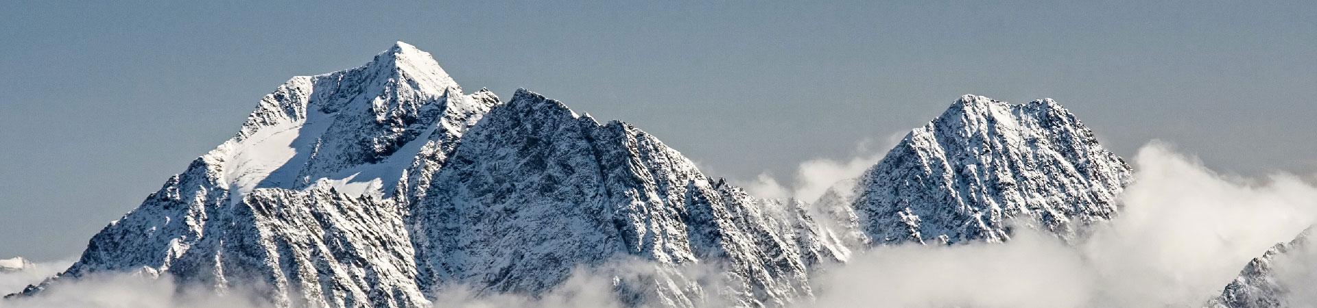
From Stella Point, the trail ascends to Uhuru Peak, which is the highest point in Africa at 5,895 meters (19,341 feet). The hike to Uhuru Peak is steep and challenging, but it is also a very rewarding experience. Accomodation will be at Mweka camp
Inclusion
Accomodation stated in the itinerary 7 days machame
All meals and drinks
Exclusions
laundry
flight in
flight out
Tips for porters and guides
Reviews
By filling out this form, you’ll be sending an enquiry to Jaynevy tours who will be able to provide you with more information about this expedition.
Expedition Information
$1,673
Kilimanjaro
Climbing,
Trekking,
Mountaineering
Fitness Level
3
Technical Level
1
Group Size
3-40
Ratio
7:7

Continent:
AfricaCountry:
TanzaniaLocation:
KilimanjaroElevation:
5,895 m / 19,340 ftGPS:
-3.06743 N°, 37.3556 E°