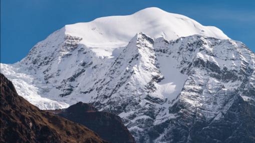
Saula (SAUL) is a climbing peak in the Manaslu mountain range of Chum Nubri municipality of Gorkha district in Nepal. The mountain peak is 6235m and can be located at latitude 28.6139 and longitude 84.7561. The summit of Saula Peak offers stunning views of Mount Larkya Peak 6416m, Manaslu 8163m, Manaslu North 6994m, Simnang Himal 6251m, and more. The region habitat vegetation of Pine and Hemlock forests, White Fir, Juniper, Birch and Rhododendron, scrub, and alpine plant communities are common at the higher altitudes. The park is home to the Red Panda, Snow Leopard, Musk Deer, Himalayan Tahr, Marten, Himalayan Mouse Hare (Pika), and over 118 species of birds including the Impeyan Pheasant, Snow Cock, Blood Pheasant, and Red-billed Chough. The Saula Peak climbing expedition is 30 days challenging adventure trip. The expedition starts from Kathmandu where you will make essential backpacking and preparation. Your guide will brief you on the necessary trip details.
Itinerary
Day 01: Arrival in Kathmandu Airport and transfer to hotel accommodation in Kathmandu
Day 01: Arrival at Kathmandu Airport and transfer to hotel accommodation in Kathmandu (1400M/4593ft).
Day 02: Preparation, briefings, last-minute shopping and permit formalities.
Day 02: Preparation, briefings, last-minute shopping, and permit formalities.
Day 03: Drive from Kathmandu to Arughat (950m/3117ft) 7hrs. Tea house/camping
Day 03: Drive from Kathmandu to Arughat (950m/3117ft) 7hrs. Tea house/camping
Day 04: Trek from Arughat to Sotikhola (1165m/3822ft) 5hrs. Tea house/camping
Day 04: Trek from Arughat to Sotikhola (1165m/3822ft) 5hrs. Tea house/camping
Day 05: Trek from Sotikhola to Machhakhola(1330m/4364ft) 6hrs. Tea house/camping
Day 05: Trek from Sotikhola to Machhakhola(1330m/4364ft) 6hrs. Tea house/camping
Day 06: Trek from Machhakhola to Jagat(1350m/4430ft) 4hrs. Tea house/camping
Day 06: Trek from Machhakhola to Jagat(1350m/4430ft) 4hrs. Tea house/camping
Day 07: Trek from Jagat to Dang(2300m/7546ft) 6-7hrs. Tea house/camping
Day 07: Trek from Jagat to Dang(2300m/7546ft) 6-7hrs. Tea house/camping
Day 08: Trek from Dang to Namrung (2550m/8366ft) 6hrs. Tea house/camping
Day 08: Trek from Dang to Namrung (2550m/8366ft) 6hrs. Tea house/camping
Day 09: Trek from Namrung to Lho (3150m/10334ft) 5hrs. Tea house/camping.
Day 09: Trek from Namrung to Lho (3150m/10334ft) 5hrs. Tea house/camping.
Day 10: Trek from Lho to SamaGaun(3780m/12401ft) 4hrs. Tea house/camping
Day 10: Trek from Lho to SamaGaun(3780m/12401ft) 4hrs. Tea house/camping
Day 11: Rest and acclimatization day at Sama Gaun (3780m/12401ft) Tea house/camping
Day 11: Rest and acclimatization day at Sama Gaun (3780m/12401ft) Tea house/camping
Day 12: Trek from Sama Gaun to Samdu (3860m/12665ft) 4-5hrs. Tea house/camping
Day 12: Trek from Sama Gaun to Samdu (3860m/12665ft) 4-5hrs. Tea house/camping
Day 13: Trek from Samdu to Saula Base Camp
Day 13: Trek from Samdu to Saula Base Camp
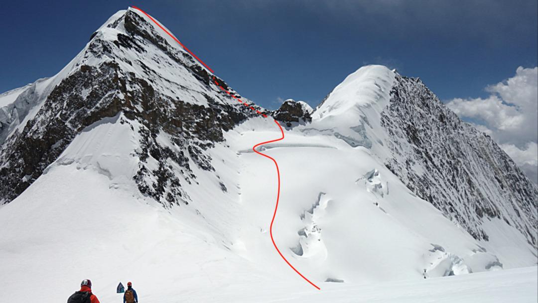
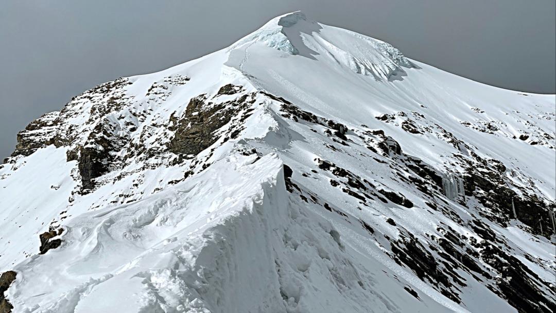
Day 14-21: Climbing period. (6235m/20456ft) Camping.
Day 14-21: Climbing period. (6235m/20456ft) Camping.
Day 22: Preparation to returning to Kathmandu. Clean base camp
Day 22: Preparation to return to Kathmandu. Clean base camp
Day 23: Trek from Base Camp to Sama Gaun (3780m/12401ft) 3hrs. Tea house.
Day 23: Trek from Base Camp to Sama Gaun (3780m/12401ft) 3hrs. Tea house.
Day 24: Trek from Sama Gaun to Namrung(2550m/8366ft) 6hrs. Tea house/camping.
Day 24: Trek from Sama Gaun to Namrung(2550m/8366ft) 6hrs. Tea house/camping.
Day 25: Trek from Namrung to Philim village (2300m/7546ft-06hrs) Tea house/camping.
Day 25: Trek from Namrung to Philim village (2300m/7546ft-06hrs) Tea house/camping.
Day 26: Trek from Philim Village to Machakhola(1330m/4664ft) 6hrs. Tea house/ camping
Day 26: Trek from Philim Village to Machakhola(1330m/4664ft) 6hrs. Tea house/ camping
Day 27: Trek from Machakhola to Arughat (950m3117ft) 8hrs. Tea house/camping.
Day 27: Trek from Machakhola to Arughat (950m3117ft) 8hrs. Tea house/camping.
Day 28: Drive from Arughat to Kathmandu (1350/4429ft) 7 hrs. Hotel accommodation in Kathmandu.
Day 28: Drive from Arughat to Kathmandu (1350/4429ft) 7 hrs. Hotel accommodation in Kathmandu.
Day 29: Free day in Kathmandu. Farewell celebration dinner with cultural program in the evening.
Day 29: Free day. Relax and shop in Kathmandu. Farewell celebration dinner with cultural program in the evening.
Day 30: Transfer to KTM airport for final departure.
Day 30: Transfer to KTM airport for final departure.
Inclusion
- • Arrival & Departure: Airport - Hotel transfers – Airport (Pick Up and Drop).
• Hotel Accommodation in Kathmandu: 3 nights hotel in Kathmandu on bed & breakfast Basis-Twin Bed Room.
• Welcome Dinner: One Welcome Dinner in a tourist standard restaurant in Kathmandu with Office Staff.
• Permit: Expedition Royalty and permit of Nepal Government to climb Saula Peak, TIMS Card, Manaslu, and Annapurna conservation area entry permit & fee.
• Insurance: Medical and emergency rescue Insurance for all involved Nepalese staff during the trek and climbing.
• Map: Trekking and climbing map.
• Member transportation:
1. Land Transportation: Drive from Kathmandu – to Arughat and While returning Drive from Arught to Kathmandu, as per itinerary.
• Climbing Stuffs Transportation: Necessary all equipment Transportation for all Members and staff from Kathmandu to Arughat (Drive) and Base camp (by Porters / Mule) – While returning: Base camp to Arughat (by porters / Mule) and Arught to Kathmandu (Drive).
• Member Luggage: Up to 30 Kg per member for personal baggage during the trek carried by porter or Mule.
• Food and Lodging: Food 3 meals a day (BDL; including tea and coffee) along with accessible accommodation at Hotel/Lodge/Tea house/Camp during the trek and BC. Well-managed base camp set up for members and staff.
• All Necessary equipment for Camping during the trek.
Exclusions
- Airfare: International flight airfare (from and to Kathmandu).
- Nepal entry Visa fee: Nepali Visa fee is US$ 40 per person for 30 days (to be applied for 60 days (USD$ 100).
- Lunch & Dinner: Lunch & dinner during the stay in Kathmandu (also in case of early return from Trekking / Expedition than the scheduled itinerary).
- Extra night in Kathmandu: Extra nights’ accommodation in Kathmandu. In case of early arrival or late departure, early return from Trekking / Expedition (due to any reason) than the scheduled itinerary.
- Insurance: Travel and high altitude insurance, accident, medical & emergency evacuation.
- Rescue Evacuation: Medical Insurance and emergency rescue evacuation cost if required. (Rescue, Repatriation, Medication, Medical Tests, and Hospitalization costs.)
- Personal Expenses: Telephone, Internet, battery recharge, shower, Laundry, any Alcoholic beverages, Clothing, Packing Items or Bags, Personal Medical Kit, Personal Trekking /Climbing Gear.
- Filming: Special Filming, Camera, and Drone permit fee.
- Internet Service: Internet facilities during the trek are not included.
- Summit Bonus: The Summit bonus for climbing Sherpa is $300.
- Tips: Calculate some tips for Base camp staff.
- Extra: Any other services or activities, that are not mentioned in the itinerary.
- Any other item not listed in the “Cost Includes” section.
Reviews
By filling out this form, you’ll be sending an enquiry to Asiana Nepal Treks & Expedition Pvt. Ltd. who will be able to provide you with more information about this expedition.
Expedition Information
$6,590
Manaslu Circuit
Mountaineering,
Trekking,
Climbing,
Skiing,
Driving,
Other (MTB, Kayak, 4WD Safari, Paragliding, Helicopter...etc)
Fitness Level
2
Technical Level
2
Group Size
2-10

Continent:
AsiaCountry:
NepalLocation:
Manaslu CircuitElevation:
5,106 m / 16,752 ftGPS:
27.7194 N°, 85.3217 E°